
Soil
erosion specialist orchestrates an informative seminar
Dr. Velibor Spalevic (a specialist in soil erosion and conservation) of the Biotechnical Faculty at the University of Montenegro had a detailed schedule planned out for my six day visit in September. We would travel by car from Podgorica, the Montenegrin capital, to Bosnia, Croatia, and Albania prior to heading to the mountains of northern Montenegro where he owns a cabin at a ski area. However, before we left on our road trip, Velibor had scheduled a seminar at the Biotechnical Faculty in Podgorica titled, “Global Problem of Soil Erosion with Special Attention to the Southeast European Region”. He and I were to speak at the seminar along with Dr. Budimir Fustic, a soil scientist with the Biotechnical Faculty, and Klaas Annys, a geography grad student at Ghent University in Belgium.
He followed up with a presentation of
research he had conducted with Dr. Fustic titled “Soil Erosion in Montenegro
with Special Reference to the Problem of Erosion in the Polimlje Region.” As part of his doctoral thesis, Velibor had
developed a computer model which he named IntErO (an acronym for “intensity of
erosion and outflow”). This program
predicts maximum (peak) runoff from 5, 10, 20, 25, 50, and 100 year storms for
a stream basin and the intensity of soil erosion in the basin. Numerous inputs
go into the program which can be summarized as:
- climate factors (including temperature and rainfall)
- geological & pedological (soil) features
- type of vegetative cover and its condition
- physical and geometric parameters of each watercourse and river basin
To demonstrate the workings of the model, it was applied to 57 sub-basins of the northerly flowing River Lim, including a region of 2,158 km2 (830 miles2) in northeastern Montenegro. (Slightly more than 50% of drainage from Montenegro flows to the north to the Danube River, and ultimately to the Black Sea; the remainder flows south to the adjacent Adriatic Sea.) The results for the 57 sub-basins predicted soil erosion ranging from 37 m3/km2/year (3400 feet3/mile2/year) to 296m3/km2/year (27,193 feet3/mile2/year). Thus, predicted soil erosion in the latter basin was eight times that of the former.

Dr. Velibor Spalevic (a specialist in soil erosion and conservation) of the Biotechnical Faculty at the University of Montenegro had a detailed schedule planned out for my six day visit in September. We would travel by car from Podgorica, the Montenegrin capital, to Bosnia, Croatia, and Albania prior to heading to the mountains of northern Montenegro where he owns a cabin at a ski area. However, before we left on our road trip, Velibor had scheduled a seminar at the Biotechnical Faculty in Podgorica titled, “Global Problem of Soil Erosion with Special Attention to the Southeast European Region”. He and I were to speak at the seminar along with Dr. Budimir Fustic, a soil scientist with the Biotechnical Faculty, and Klaas Annys, a geography grad student at Ghent University in Belgium.
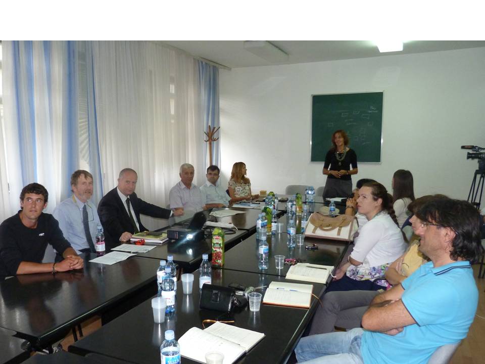 |
The four speakers at the seminar are seated on the left.
From left to right: Klaas Annys, me, Dr. Velibor Spalevic, and Dr. Budimir Fustic.
Dr Biljana Lazovic (standing) welcomed the speakers and guests.
|
In addition to the four speakers, there
were about 12 people attending from the Biotechnical Faculty as well as the
Montenegrin Ministry of Agriculture and Development and the Ministry of
Environment. There was also a camera
crew from the National TV Service of Montenegro and segments of the seminar
(including individual interviews) subsequently aired on six national TV
channels. I was learning that Velibor
was “very well connected” in Montenegro and was quite adept at bringing people
together and making things happen. I
later learned that he had previously worked as a Task Manager for the
Delegation of the European Union to Montenegro – not surprising given his
outgoing and forceful personality.
For the benefit of those who were not
specialists in erosion, Velibor led off the seminar with a short but very
helpful introduction titled, “What is Soil Erosion?”
 |
| Velibor Spalevic included some dramatic slides in his introductory presentation on soil erosion. |
- climate factors (including temperature and rainfall)
- geological & pedological (soil) features
- type of vegetative cover and its condition
- physical and geometric parameters of each watercourse and river basin
 |
Location of the Lim River basin (circled in red) in northeastern Montenegro.
Slide from Velibor Spalevic’s presentation.
|
To demonstrate the workings of the model, it was applied to 57 sub-basins of the northerly flowing River Lim, including a region of 2,158 km2 (830 miles2) in northeastern Montenegro. (Slightly more than 50% of drainage from Montenegro flows to the north to the Danube River, and ultimately to the Black Sea; the remainder flows south to the adjacent Adriatic Sea.) The results for the 57 sub-basins predicted soil erosion ranging from 37 m3/km2/year (3400 feet3/mile2/year) to 296m3/km2/year (27,193 feet3/mile2/year). Thus, predicted soil erosion in the latter basin was eight times that of the former.
 |
Table from Velibor Spalevic’s presentation showing the predicted maximum flows for 5, 10, 20, 25, 50, and 100 year storms for each of the 57 sub-basins of the Lim (a "5 year storm" is the largest storm, and resulting peak volume of stream flow, to occur during any 5-year period). On the right, the colored bars indicate the predicted annual soil loss per square kilometer for each sub-basin. The nine red bars represent sub-basins which would experience the most severe soil loss (greater than 200m3/km2/year) as calculated by the IntErO model.
|
Applications
& opportunities for erosion control professionals
I can envision some very practical applications
for this model. Land management
officials, such as the three extension agents from the Ministry of Agriculture
and Development who attended the seminar, can use these results to prioritize
their efforts to control soil erosion by working with local farmers where predicted
erosion is the most serious. I could
imagine a government program focusing on reduction of soil erosion in the nine
Lim sub-basins out of 57 where predicted erosion exceeds 200m3/km2/year. Such a program would concentrate efforts
where they are most needed and would preserve valuable topsoil, improve
downstream fisheries, and reduce sedimentation behind hydroelectric dams to the
north.
I suspect that part of the problem in
these nine sub-basins is poor agricultural practices (such as those shown in
the photo in southern Serbia in my last blog post). However, there may be other culprits as well
such as failure to re-vegetate highway cuts and fills in the mountainous
terrain, mining scars, forest clear-cutting, mountain recreational development,
or commercial/industrial projects. I’m
speculating since I have not visited these sub-basins or discussed specifics
with Drs. Spalevic or Fustic.
 |
Top photo: Normal flow on the River Lim at the village of Rudeš in February 2011.
Bottom photo: Same location two months earlier with the river at flood stage.
Photos by Velibor Spalevic.
|
Off the top of my head, I see an
opportunity for a SOIL Fund project in this area of Montenegro. Spalevic and
Fustic’s data identifies nine sub-basins with relatively severe erosion
problems. Some of these problems may
lend themselves to the kinds of solutions with which IECA professionals have
experience. What if an IECA professional
were to visit some of these impacted sub-basins under the direction of Spalevic
and Fustic, identify sites that would lend themselves to erosion control
through bio-engineering or other erosion control BMPs (Best Management
Practices), and propose treatment plans?
With these plans in hand, we could approach European manufacturers of
erosion control BMPs to see if they would be willing to donate materials or
supply them at a reduced cost in return for free publicity. The IECA professional in charge could then
return to Montenegro and work with local contractors and volunteers to carry
out treatment plans. Faculty and
students at the University of Montenegro could also be involved. Of course, we would need to find funding to
pay contractors and the expenses of other people involved.
Obviously, this needs more thought and up-front
collaboration with Spalevic and Fustic. I
would suggest that a “working vacation” in Montenegro with its rugged
mountains, dramatic coastline along the Adriatic, and hospitable people could
be a very rewarding experience for one of you readers!
Other
seminar presentations
Velibor Spalevic also gave a
presentation on the IntErO program explaining the theoretical background
including the mathematical formulas used by the model and the data inputs. He also discussed the advantages of IntErO over
other mathematical models for calculation of runoff and erosion.
From 2002-2004 (following the Polimlje
study), Fustic and Spalevic were funded by the Montenegrin Ministry of Science
to study erosion in several river basins along the Adriatic Coast. Dr. Fustic presented the results to us in
Montenegrin (the other presentations were in English). Again, the IntErO model was used to process
and analyze the data.
 |
Slide from Budimir Fustic’s presentation
showing severe gully erosion near the Adriatic coast.
|
 |
I’m presenting the results of my evaluation of erosion problems in a mountain community
in Ecuador while Valibor Spalevic (to my left) translates from English to Montenegrin
(a dialect of Serbian). Photo provided by Dr. Milic Curovic of the Biotechnical Faculty.
|
I discussed the results of my
reconnaissance of soil erosion problems in the Malingua Pamba community in the
Ecuadorian Andes (a joint project of the IECA SOIL Fund and Engineers Without Borders). Finally, Klaas Annys
gave a nicely photo-illustrated presentation on the geomorphology of the
Durmitor Mountains in northwestern Montenegro.
Klaas is doing research in this mountain range for his Master’s thesis
specifically focusing on Montenegro’s only glacier. In a future post, I will report on my hike
with Klaas to this little glacier which sits in a narrow valley nearly surrounded
by jagged limestone peaks.
 |
Klaas Annys standing at the foot of Montenegro’s only glacier
located in the Durmitor Mountains.
|
 |
The Biotechnical Faculty at the University of Montenegro publishes
the bi-lingual (Montenegrin and English) journal Agriculture and Forestry.
It is available on-line at http://www.agricultforest.ac.me
|