Showing posts with label Erosion and community developement. Show all posts

Saturday, January 25, 2014

Mexico: New SOIL Fund Work in Oaxaca

My apologies for neglecting my blog for several months.  Fortunately, my colleague Julie Etra has come to the rescue with the following blog post regarding her SOIL Fund volunteer work in southern Mexico.  Julie is the Region 1 Vice President for International Development with the International Erosion Control Association.  - Will

The SOIL Fund has completed 5 Vetiver plantings in and around the southern Oaxacan town of Huatulco, Mexico. Four of the five plantings include nurseries, while three are demonstration projects. Vetiver, a grass native to India, has long been known for its excellent erosion control characteristics, and due to its form (bunch) and lack of seed production is not invasive and will not outcompete native species.

The SOIL Fund hopes that through education and dissemination, the use of this plant will be increased to control erosion on slopes destabilized from road construction, cultivation, and logging.

 
Sign advertising SOIL Fund work at Copalita, near Huatulco, Mexico.  Pictured are Cornelio Gabriel Ramos and his son, Christian Tadeo.  Cornelio is a local bird guide (pajarero). 
photo by Julie Etra.


Friday, November 16, 2012

India: Erosion Control Incorporated into Planned Community


Some Background on My Visit
During the February 2012 IECA conference in Las Vegas, I spoke with C.R. Devaraj, President of IECA’s Indian Chapter. Devaraj is the Managing Director of Charankattu Coir Mfg. Co. located in the state of Kerala in southwestern India and he was attending the conference to promote his company’s erosion control blankets made from local cocoanut and jute fibers.

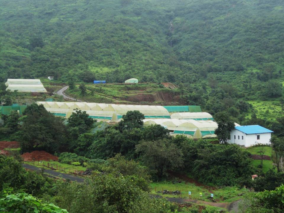
I had one question for C.R. Devaraj:  “Were I to visit India this year, could you recommend any projects I could see which are successfully employing erosion control techniques and products?”  He immediately replied, “Yes, Lavasa.”  He told me a bit about the project and I looked at its website where I learned that Lavasa is a planned community in the Western Ghats, a chain of low mountains east of Mumbai (Bombay) and near the city of Pune.

C.R. Devaraj provided me with contact information for Lavasa and I eventually secured an invitation to visit the community from Krunal Negandhi, Lavasa’s Assistant VP for Projects (Environment).  I later learned that two IECA members had been directly involved with the project.  C.R. Devaraj had supplied the erosion control products used at Lavasa -- the first time he had actually provided products for an Indian project.  Also, Doug Wimble (Managing Director of Spraygrass in New South Wales, Australia and the new President of IECA’s Region 2) had provided consulting services for Lavasa’s erosion control efforts.


When I visited Lavasa in August 2012, Krunal Negandhi and his associates bombarded me with a wealth of interesting information regarding the philosophy behind the project, its objectives, progress to date, specific erosion and sediment control measures, various other environmental measures, and other important information about the community.  They also took me for several site tours to give me a first-hand look at the results of their efforts.  It would take many pages to describe their initiatives with regard to sustainable native vegetation, solid waste management and recycling, sewage treatment, renewable energy, education, health care, light industry using local materials (bamboo) and tourism.  I’ll focus on erosion and sediment control but first here is a summary of how Lavasa got started and what the project hopes to achieve.

Central pedestrian area in Lavasa with scores of condos and homes (most under construction) in background.
 

Krunal Negandhi, Lavasa's Assistant VP for Environment and a view of Warasgaon Lake on a foggy morning.
 

Members of Lavasa’s environmental team pose in front of some of their successful reclamation work.  From left to right:  Aalam Tamboli, Pramod Pokharkar, Sunil Habade, and Satish Killare   Photo provided by Krunal Negandhi.
 
A Very Brief History of Lavasa
In 1998, the government of India initiated a new Hill Station Policy to encourage the development of planned communities accessible to, but separated from, huge chaotic, unplanned, and relatively dysfunctional cities such as Mumbai. The idea for Lavasa was conceived by Mr. Ajit Gulabchand, the Chairman of Hindustan Construction Company.  He envisioned a community which would integrate living, working, and playing in harmony with nature. 
 
Construction of Lavasa started in 2002.  It is the first open (un-gated) community initiated under the Hill Station Policy.  It is also India’s first city built and governed by a private corporation.  The developers are trying to achieve environmental sustainability based on principles of the UN Environmental Program.
 
Lavasa has had its share of problems.  Construction was shut down for a time because clearances had not been granted by all the necessary departments of the notorious Indian bureaucracy.  A July 2011 article in Atlantic Magazine criticized Lavasa for constructing housing that is too expensive for the average Indian.  True enough, but I was shown modest low-cost apartments that are being provided for construction workers and other laborers.  It seemed to me an improvement over communities like Aspen and Vail, Colorado, USA where workers can’t afford local housing and have to commute to work an hour or more from trailer parks or crowded apartments where land is cheaper.  Lavasa may not be perfect but they are trying to provide an innovative model for future urban development in India.  We’ll have to check back in a few years to see how well they are succeeding.
 
Erosion and Sediment Control at Lavasa
When work started at Lavasa in 2002, erosion and sedimentation had significantly degraded the mountainous landscape where slash and burn agriculture was the norm.  Addressing these problems had been integrated into the community master plan.  For example, there would be no construction on slopes greater than 1:3 (33% or 18.4o).  Existing green cover would be preserved where possible.  Reforestation with indigenous species was planned for steep, denuded slopes.  Measures would be introduced to raise the water table providing needed moisture for re-vegetation efforts.  Vegetated buffer zones would be created or maintained around streams to minimize sedimentation. 
 
I saw a number of sites where these elements of the master plan have been implemented.  Following are examples of some of the specific erosion and sediment control measures employed.


This steep soil dump (fill) slope above the city center has been transformed into a stable green carpet of trees and plants.  Here’s how they accomplished it:
- First, they graded the slope into the undulating surface shown in the above photos
- A jute bag toe wall was constructed at the base of the slope.  The jute bags were filled with excavated (reused) soil and wrapped with geo-mating. 
- Cocoanut coir mats were anchored to the slope above the jute bag wall.
- Vetiver (the tall grass in the photos) was planted at the base of the slope and immediately above the jute bag wall. Vetiver is famous for its long roots which counteract surface erosion.  It is unable to reproduce itself so it does not spread to areas where it is not wanted.
- The hillside was hydroseeded with a mix containing paper mulch, wood fiber, water, seed of indigenous species, and guar gum binder with rice husks.  It was seeded right after the monsoon rains started in the spring.
- Native trees were planted in scattered locations.
- A drip irrigation system was installed to help the plants and trees survive and thrive through the four month winter dry season.


Reclaimation work is underway on this hillside.  Note the jute bag wall with jute netting above on the steep hillside.


Biodegradable bamboo staples are used to anchor mats to the hillsides.


Horizontal PVC pipes with filter media extend 0.9 meters (about 3 feet) back into a jute bag wall to permit ground water drainage. 


On hillsides, water absorbing trenches (WATs) (1 meter wide and 1 meter deep) and continuous contour trenches (CCTs) (0.6 meters wide and 0.6 meters deep) trap rain water and promote infiltration.  Each trench has a maximum length of 3 meters (about 10 feet).  In areas where the trenches have been excavated, groundwater levels are rising.  They also use CCTs that drain to natural swales.


Artificial ponds and structures have been constructed along existing drainages.  These features reduce erosion by slowing down storm water runoff.  They increase infiltration, retain some water in these intermittent streams during the dry season, and enhance the aesthetic character of landscape.
 

A gabion bandhara and loose boulder structure covered with wire mesh has been constructed across an intermittent stream in the valley below a steep hillside.  Note the sediment which has collected above the dam.  Previously, the sediment would have reached Warasgaon Lake in the valley bottom.

 
Lavasa’s “leisure trail” winds along a steep mountainside which was an eroded, barren wasteland prior to reclamation four years ago and is now covered by a dense and diverse young forest.  The pathway was constructed with soil jute bags wrapped with geo-mats and covered with gravel.  The path is “stepped” to cut down on erosion.
 
 
Initially, the project team tended to rely on more traditional methods for slope stabilization such as this gabion wall next to a street.  In recent years, they have been switching to more aesthetically-pleasing, environmentally-sustainable bioengineering techniques.
 
 
Bio-diversity enhancement:  Approximately 600,000 indigenous trees and 700,000 stumps and shrubs have been planted.  The aim is to create a diverse canopy structure of trees, shrubs, and grasses.
 
Lavasa hires local people to do the planting by hand.  Farm yard manure and local mulches are used.  Some areas also require geo-mats or coir mats depending on slope and other factors.
 
In the photo above, the left side of the stream is reforested Lavasa property.  The right side is owned by local farmers and has been cleared (slash and burn) for grazing.  The grazing land is green because the photo was taken in the middle of the rainy season.  A close look reveals evidence of erosion on the recently grazed hillside. Lavasa personnel are working with local farmers to steer them away from slash and burn practices.
 
 
Lavasa has its own nursery where ornamental plants as well as native species for reforestation and erosion control get their start.  Photo provided by Krunal Negandhi.


Saturday, November 10, 2012

India: An Important Role for Erosion and Sediment Control in Community Development

In 2011, more than a year before I departed on my around-the-world trip for the SOIL Fund, I learned about a watershed management project in India sponsored, in part, by a Colorado Rotary Club.  I found out from Irv Buck, a Rotarian from Parker, Colorado, that the project included erosion and sediment control measures that played an integral part in the improvement of agricultural productivity, groundwater resources, and water quality. 

The project is located in a rural community in the Thane District a few hours north of Mumbai (Bombay), and I hoped to visit it while in Mumbai at the end of August.  Irv put me in touch with Arobina Sinha Roy of the Rotary Club of Bombay Midtown.  Mr. Roy, (better known as “Arrow”), a retired advertising executive, doubted I would be able to visit the community.  The problem was the timing of my visit during the monsoon season.  Roads into the community would be in poor shape after being pounded by monsoon rains for the three months before my visit.  As a result, the Mumbai Rotarians generally only went there during the dry season.  However, Arrow was interested in meeting me, and I had the pleasure of having lunch with him during my visit to Mumbai.
 
Rotary’s watershed development project
is located 115km (70 miles) north-northeast of Mumbai.
Arrow brought along his laptop to our lunch meeting, and I was treated to a photo-illustrated PowerPoint presentation.  I learned that there are 672,000 villages in India where 70% of the population lives.  About 50% of these villages have no support systems.  The government has built poorly-conceived water impoundment dams in many of these villages but they often silt up and become useless within a few years partly because there are no erosion and sediment controls upstream.  Government corruption and local “mafias” impede village improvements and most people have no legal recourse because the courts are hopelessly clogged.

Thane District Watershed Development Project
Thus, the Rotary Club of Bombay Midtown decided to bypass the government and start to attack rural Indian poverty in the local region.  Their first project involves 672 hectares (1680 acres) in the villages of Potkhal and Baste.  It was conceived in 2005 and most of the work has now been completed.  Rotary chose this poor community because the local residents had some education, a common culture, and a lack of political problems.  Furthermore, women were already involved in community decision making.

Several Rotary Clubs from India, the USA,
and Switzerland have been involved with the project.
The original objective was to improve the community’s drinking water system.  The water table had been dropping about two feet per year meaning that the community well went dry earlier and earlier every year once the dry season set in.  As a result, women had to walk 2 to 3 miles just to find water in ponds where cattle also drank.  The community economy was stagnant because lack of water limited the farmers to one crop per year.  Furthermore, 65% of the people were landless and in debt.


Village women used to walk 2 or 3 miles to get drinking water from this foul pond. 
It soon became apparent to Arrow and his colleagues that providing better drinking water was a starting point but much more was required.  The landscape had been denuded by deforestation some of which was caused by crooked timber companies who had purchased land cheaply from poor villagers who needed cash.  Problems in the community required a holistic approach which would enable the local economy to grow rapidly and address other essentials such as health care and education.  With the Bombay Midtown Club taking the lead, a $137,000 grant was obtained from the Rotary Foundation for a Watershed Management Project.

Role of Erosion and Sediment Control BMPs
Use of standard erosion and sediment control best management practices (BMPs) like check dams and infiltration trenches played a large role in the project.  As Arrow explained it, they had to “teach the rain to walk”.  By slowing down or impounding runoff, groundwater recharge improved and the water table is now rising.  Wells now dry up in May (near the end of the dry season) instead of February (middle of the dry season).  Women no longer have to haul contaminated drinking water from distant locations.  Improvements in recharge will eventually result in a year round supply of well water.
If you look closely, you can see newly-constructed check dams
in the drainages of this deforested hillside.
 
Infiltration trenches constructed along the contour not only slow down runoff
but also help with groundwater recharge.
 
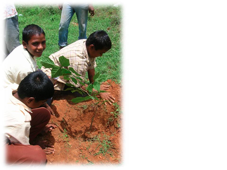
This more reliable water supply has enabled farmers to improve crop yields by 20% and raise two or three crops per year.  As a result, they now produce surpluses providing them a cash income.  An associated reforestation project provides a sustainable supply of timber for local use and for sale outside the community.  80,000 saplings have been planted on more gentle slopes while vetiver grass is used to stabilize relatively steep slopes.  These revegetation efforts help to enable rain water to “walk” down the slopes and improve infiltration.


Community boys planting saplings.  After 2012, ¼ of the trees grown for firewood will be harvested annually and new saplings will be planted to replace them.


Reduction of soil erosion in the community and sedimentation in local streams and reservoirs are secondary benefits of the watershed management program.  However, I find it very significant that the BMPs we use to control erosion and sedimentation on construction projects in “Western” countries, can play a central role in providing potable and irrigation water to rural communities in developing countries.  


My thanks to Irv Buck of the Parker, Colorado (USA) Rotary Club for providing all the photos used in this story.


A build-up of sediment behind this new community dam will still be a problem
but erosion control BMPs in the watershed above the dam will extend its life.
 
Surplus water is enabling community women to plant “kitchen gardens”.


Thursday, September 6, 2012

Bali (Indonesia): An English visionary, his dedicated staff, and a rural community tackle poverty and soil erosion

My old college friend, Bruce Briscoe, is a member of the Ubud Sunset Rotary Club in Bali, Indonesia.  Bruce put me in touch with Sue Winski, another Rotary member, who arranged for me to give a presentation on the SOIL Fund at a Rotary Club meeting while I was in Bali in early August 2012.  Sue also put me in touch with David Booth, an English ex-pat, civil engineer, and founder of the East Bali Poverty Project (EBPP).

A poor community within a tourist destination
Poverty in Bali?  Much of Bali prospers from tourist dollars, and the Indonesian government wants to project a picture of happy Balinese people to potential tourists.  According to David Booth, the Indonesian government had published data in the 1990s claiming that no poverty existed in Bali.  They reasoned that aid organizations working with malnourished children would hurt the island’s image with tourists.  In response to the data, many aid organizations working in Bali pulled out in 1995. 

David had been living in Bali for several years and knew that the government’s rosy image of the island didn’t hold water.  After doing his own research, he identified Desa Ban in the northeastern corner of Bali as the poorest community on the island.  In 1998, he founded the East Bali Poverty Project (EBPP) to provide a comprehensive approach to the economic, social, and environmental problems of Desa Ban.    
David Booth, EBPP Founder and CEO, with his able Balinese assistants, Ketut Suastika (left) and Nengah Ardika Adinata (right).  Nengah and Ketut are wearing jackets and scarves because the morning air (around 20oC – high 60s F) feels cold to Balinese when they ride their motor bikes at 900 meters elevation (2900ft).

Desa Ban’s misfortunes were closely related to the circumstances of its geography.  The community is located between two towering volcanic peaks (Abang and Agung) on slopes averaging 30o (67%).  During the rainy season, it is sometimes hammered by catastrophic floods, while streams disappear during the dry season and the porous volcanic soils lose all the moisture needed to grow crops. 
Mount Agung (3150m – about 10,000ft) provides an idyllic backdrop to the east Bali community of Desa Ban.

Prior to EBPP’s involvement, the villagers eked out a precarious existence growing cassava and maize (corn) and were limited to one crop per year.  There were no roads, no schools, no sanitation, and no health care facilities for the 15,000 people spread out in Desa Ban’s 19 villages over an area of 7200 hectares (18,000 acres). Child mortality was 30-50% before age one and many kids were covered with sores.  Because the nearest reliable springs were too far from the community to provide a regular source of water, people gathered rainwater from their roofs for domestic use.  Rainwater lacks some of the essential minerals needed for human health, especially iodine.  Thus, goiter was rampant in the population and many children suffered from iodine deficiency disease.

Attacking poverty at Desa Ban
After identifying these issues, David went to the community and asked what they needed to improve their lives.  They replied that their top priorities were education for their children and better farming techniques.  Thus, rather than deciding himself what was best for the community, David involved the local people early in the process which gave them “ownership” of the project.

Obviously, attacking such problems took a lot of bucks, and David has been quite successful in finding funding sources such as UNICEF and the British embassy in Indonesia.  He has also raised money by providing consulting services to mining companies, resorts, and other commercial enterprises in Indonesia showing them how to use vetiver grass to stabilize mine tailings and absorb sewage waste.

In the 14 years since the EBPP was founded, the results have been impressive:
- Childhood vaccination rates are now 100% and child mortality has been virtually eliminated.
- 27 health centers have been established in the community promoting tremendous improvements in maternal and child health.
- UNICEF has provided iodine tablets eliminating iodine deficiency-related health problems.
- More than 200 previously illiterate children, ages 6 to 15, attend six schools scattered in hamlets around the community.
- Safe drinking water from three mountain springs now serve 1500 families and more than 850 appropriate technology rainwater collection reservoirs have been built providing a year-round source of domestic and irrigation water.
- Crops have been diversified and up to three crops per year can now be produced.  Organic gardening using worm composting is flourishing on rehabilitated farmland.
- More than 25km of improved roads now link 19 hamlets in the community with each other and the outside world.
- Solar power has been provided to hamlets which have no connection to the electrical power grid.
- Reforestation with bamboo has rejuvenated the local ecosystem and provided a sustainable community industry which produces bamboo for construction uses.
 
“We love you foreigners! Just keep providing
the iodine tablets and vaccinations for our kids.”


Village school in Damaji village. Another dozen years of practice
and she may be on stage in an ornate costume interpreting traditional Balinese dances.
New bridges and improved roads are providing
better access to markets and services for the people of Desa Ban.


Vetiver!
What does Desa Ban’s success in battling poverty have to do with erosion control?  First of all, soil erosion was one of the significant elements related to the community’s desperate situation.  Clearing the mountainsides of their natural protective cover of vegetation to grow cassava and maize had resulted in a loss of the rich volcanic topsoil over time.  With topsoil being gradually being lost by erosion, crop yields had nowhere to go but down.
Sustainable agroforestry on a steep hillside in Desa Ban.

EBPP has greatly reduced soil erosion by the introduction of agricultural terraces which retain water and are protected by vetiver grasses.  Vetiver is valued throughout tropical Asia for its deep roots which do an excellent job of holding soil in place and retaining soil moisture.  Desa Ban has vetiver nurseries where the grasses are started from shoots and eventually transplanted to terraces and slopes which need stabilization.  I saw the effective use of vetiver in the community and was very impressed.  These grasses are providing long-term stability to agricultural land in Desa Ban and have the potential to save millions of tons of topsoil in tropical areas. 

The EBPP website (http://eastbalipovertyproject.org) provides a helpful description of vetiver and its very useful qualities:  Vetiver is a fast growing clump grass with sterile seeds that make it impossible for the plant to spread like a weed.  With a dense and deep root system (penetrates up to 3 meters below the ground surface) it is able to prevent against erosion and landslides.  Through this function, vetiver has also enabled the building of protected roads, fortification of fertile farmland, and flood protection.  Beyond this, vetiver acts as a purifying agent, improving soil fertility and water quality, and is one of the most effective natural methods of carbon sequestration.  Vetiver is also harvested in a variety of ways that can provide building materials and crafts that can be sold to help stimulate the local economy.
Deep-rooted vetiver grass planted along the outer edge of agricultural terraces holds topsoil in place.


I hope that erosion control specialists can find inspiration from the successes in Desa Ban.  Whether we are botanists, soil scientists, civil engineers, geologists, etc., we should contemplate lending our talents to groups working with poor communities in developing countries. 

And by the way, David is looking for volunteer help from a specialist in “rainwater harvesting” if you know anyone with that skill.